Contact | RSS | EN | DE | EL | ES | FR | IT | RU

Mag. 3.8 earthquake - Mexico: 10 Km Al NORESTE De CUERNAVACA, MOR, on Monday, Oct 16, 2023, at 07:19 am (Mexico City time) -

A moderate magnitude 3.8 earthquake hit 9.6 km (6 mi) away from Cuernavaca, Morelos,  Mexico, in the morning of Monday, Oct 16, 2023 at 7.19 am local time (America/Mexico City GMT -6). The quake had a very shallow depth of 3 km (1.9 mi) and was reported felt by some people near the epicenter.

Mag. 3.8 earthquake - Mexico: 10 Km Al NORESTE De CUERNAVACA, MOR, on Monday, Oct 16, 2023, at 07:19 am (Mexico City time) Mag. 3.8 earthquake - Mexico: 10 Km Al NORESTE De CUERNAVACA, MOR, on Monday, Oct 16, 2023, at 07:19 am (Mexico City time)
Light magnitude 3.8 earthquake at 3 km depth
16 Oct 17:14 UTC: First to report: SSN after 4 hours.

Earthquake details

Date & timeOct 16, 2023 13:19:39 UTC -
Local time at epicenterMonday, Oct 16, 2023, at 07:19 am (America/Mexico City GMT -6)
StatusPreliminary (automatic detection)
Magnitude3.8
Depth3 km
Epicenter latitude / longitude19.01°N / 99.21°W Huitzilac, Morelos, Mexico
Seismic antipode19.01°S / 80.79°E
Shaking intensityV Moderate shaking near epicenter
Felt2 reports
Primary data sourceSSN (Servicio Sismológico Nacional)
Nearest volcanoChichinautzin (11 km / 7 mi)
Estimated seismic energy released3.2 x 1010 joules (8.78 megawatt hours, equivalent to 7.56 tons of TNT) | about seismic energy
[smaller] [bigger]

Nearby places

The closest larger town where the quake might have been felt is Mexico, the capital of  Mexico with 12,000,000 inhabitants, in 47 km (29 mi) distance north of the epicenter. People likely experienced very weak shaking there. Many smaller towns and villages are located closer to the epicenter and might have experienced stronger shaking.
The following table shows some of the places that might have been affected (or not) by the shaking.
Distance Place Max. shaking intensity(*) Region Country
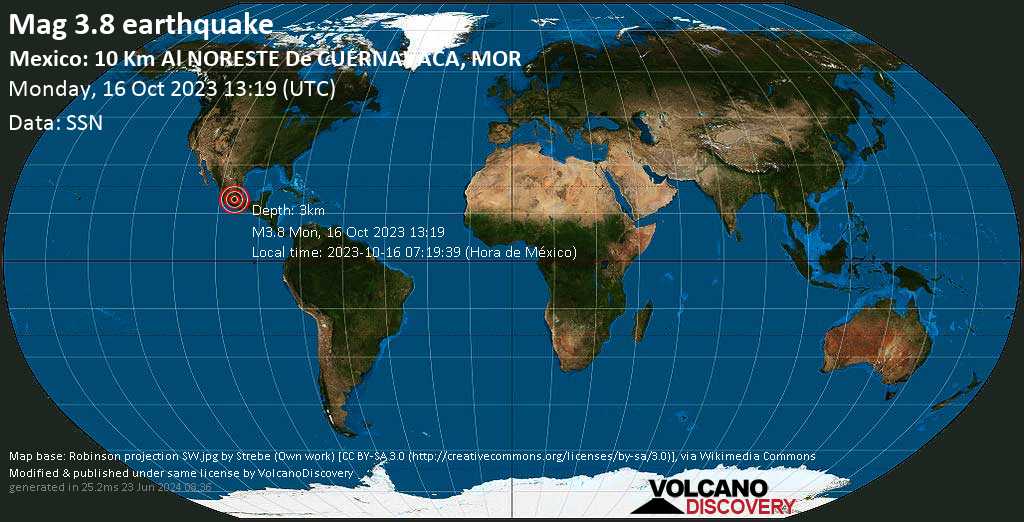
6 km (4 mi)
NW of epicenter
Tres Marias
(pop: 6,160)
IV: Light
Huitzilac, Morelos
10 km (6 mi)
S of epicenter
Cuernavaca
(pop: 338,700)
IV: Light
Morelos
15 km (9 mi)
S of epicenter
Jiutepec
(pop: 162,400)
III: Weak
Morelos
16 km (10 mi)
S of epicenter
Tres de Mayo
(pop: 18,000)
III: Weak
Emiliano Zapata, Morelos
18 km (11 mi)
S of epicenter
Temixco
(pop: 97,800)
III: Weak
Morelos
19 km (12 mi)
S of epicenter
Emiliano Zapata
(pop: 49,200)
III: Weak
Morelos
21 km (13 mi)
SE of epicenter
Yautepec
(pop: 42,700)
III: Weak
Morelos
23 km (14 mi)
N of epicenter
San Miguel Topilejo
(pop: 34,600)
III: Weak
Tlalpan, Mexico D.F.
24 km (15 mi)
NE of epicenter
San Pablo Oztotepec
(pop: 15,500)
III: Weak
Milpa Alta, Mexico D.F.
26 km (16 mi)
S of epicenter
Xochitepec
(pop: 19,200)
III: Weak
Morelos
28 km (18 mi)
NE of epicenter
Milpa Alta
(pop: 18,300)
III: Weak
Mexico D.F.
29 km (18 mi)
N of epicenter
Xochimilco
(pop: 407,900)
III: Weak
Mexico D.F.
32 km (20 mi)
N of epicenter
Tlalpan
(pop: 574,600)
III: Weak
Mexico D.F.
33 km (20 mi)
NE of epicenter
San Antonio Tecomitl
(pop: 24,400)
III: Weak
Milpa Alta, Mexico D.F.
33 km (21 mi)
NE of epicenter
San Juan Ixtayopan
(pop: 24,100)
III: Weak
Tlahuac, Mexico D.F.
35 km (21 mi)
S of epicenter
Santa Rosa Treinta
(pop: 16,700)
III: Weak
Tlaltizapan de Zapata, Morelos
36 km (22 mi)
N of epicenter
Magdalena Contreras
(pop: 238,400)
III: Weak
Mexico D.F.
36 km (23 mi)
SE of epicenter
Cuautla
(pop: 154,400)
III: Weak
Morelos
36 km (23 mi)
S of epicenter
Xoxocotla
(pop: 21,100)
III: Weak
Puente de Ixtla, Morelos
38 km (23 mi)
NE of epicenter
Tlahuac
(pop: 305,100)
III: Weak
Tlahuac, Mexico D.F.
38 km (23 mi)
N of epicenter
Coyoacan
(pop: 620,400)
III: Weak
Coyoacan, Mexico D.F.
39 km (24 mi)
E of epicenter
Yecapixtla
(pop: 16,800)
III: Weak
Morelos
40 km (25 mi)
S of epicenter
Zacatepec de Hidalgo
(pop: 21,600)
III: Weak
Zacatepec, Morelos
40 km (25 mi)
NE of epicenter
San Miguel Xico
(pop: 356,400)
III: Weak
Valle de Chalco Solidaridad, Mexico
41 km (25 mi)
N of epicenter
Delegacion Cuajimalpa de Morelos
(pop: 160,500)
III: Weak
Cuajimalpa de Morelos, Mexico D.F.
41 km (26 mi)
N of epicenter
Iztapalapa
(pop: 1,815,800)
III: Weak
Mexico D.F.
42 km (26 mi)
N of epicenter
Huixquilucan
(pop: 124,800)
III: Weak
Mexico
42 km (26 mi)
S of epicenter
Tlaquiltenango
(pop: 18,300)
III: Weak
Morelos
43 km (27 mi)
NE of epicenter
Chalco
(pop: 168,700)
III: Weak
Mexico
44 km (27 mi)
N of epicenter
Benito Juarez
(pop: 355,000)
III: Weak
Benito Juarez, Mexico D.F.
44 km (28 mi)
NW of epicenter
San Mateo Atenco
(pop: 67,900)
III: Weak
Mexico
44 km (28 mi)
N of epicenter
Iztacalco
(pop: 384,300)
III: Weak
Mexico D.F.
45 km (28 mi)
S of epicenter
Puente de Ixtla
(pop: 21,100)
III: Weak
Morelos
46 km (29 mi)
NE of epicenter
Los Reyes Acaquilpan
(pop: 85,400)
II: Very weak
La Paz, Mexico
47 km (29 mi)
N of epicenter
Miguel Hidalgo
(pop: 372,900)
II: Very weak
Mexico D.F.
47 km (29 mi)
N of epicenter
Mexico
(pop: 12,294,200)
II: Very weak
Mexico D.F.
48 km (30 mi)
NE of epicenter
Ciudad Nezahualcoyotl
(pop: 1,104,600)
II: Very weak
Nezahualcoyotl, Mexico
48 km (30 mi)
NE of epicenter
Ixtapaluca
(pop: 322,300)
II: Very weak
Mexico
49 km (30 mi)
NW of epicenter
San Salvador Tizatlalli
(pop: 61,400)
II: Very weak
Metepec, Mexico
49 km (30 mi)
N of epicenter
Cuauhtémoc
(pop: 531,800)
II: Very weak
Mexico D.F.
Notes:
(*) Shaking intensity according to the Modified Mercalli Intensity Scale (MMI) and estimated using seismic models.

User-reports for this quake (2)

We received 2 reports for this quake.
User reports estimate the perceived ground shaking intensity according to the MMI (Modified Mercalli Intensity) scale.
Contribute:
Leave a comment if you find a particular report interesting or want to add to it.
Flag as inappropriate.
Mark as helpful or interesting.
Send your own user report!
Translate
Mexico City Hotel Galeria Plaza Reforma / Weak shaking (MMI III) / horizontal (sideways) swinging / 20-30 s : significant shaking and vibration  

What is Intensity and the Mercalli Intensity Scale?


The amount of shaking that occurs on the surface due to an earthquake is called the intensity. It is commonly measured on the so-called Modified Mercalli Intensity Scale (MMI) ranging from 1 (not felt) to 10 (extreme shaking), and given in Roman numerals as I,II,...IX, X, and often displayed with color codes ranging from light blue to dark red.
Earthquake intensity depends mainly on the magnitude and depth of the quake as well as the distance from the epicenter: The further away, the less shaking intensity occurs.
Read more about the MMI scale!

Compare Quake Data

Data for the same earthquake as reported by different agencies

The more agencies report about the same quake and post similar data, the more confidence you can have in the data. It takes normally up to a few hours until earthquake parameters are calculated with near-optimum precision.
Mag Depth Time GMT
2023-10-16
Epicenter Agency
3.8 3 km
1.9 mi
13:19:39 Mexico: 10 Km Al NORESTE De CUERNAVACA, MOR SSN (Servicio Sismológico Nacional)
3.8 3 km
1.9 mi
13:19:39 Central Mexico
0 km (0 mi) epicenter difference with SSN
RaspberryShake (RaspberryShake)
3.8 3 km
1.9 mi
13:19:39 Morelos, Mexico
0 km (0 mi) epicenter difference with SSN
EMSC (European-Mediterranean Seismological Centre)

Seismograms

Seismic station: Unam - Mexico, Mexico (UNM/G network) | Distance from quake: 36 km / 22 mi | Show on map | Station Info
Seismic station Unam - Mexico, Mexico: vertical movement plot around time of quake (source: IRIS/BUD)
Seismogram (vertical component) around time of quake. Thin dotted red line indicates time of quake. Seismic waves arrive some time later, depending on distance. Bandpass filter applied: 0.5-10.0 Hz. Source: IRIS Buffer of Uniform Data (BUD) webtool
Show more

Earthquake statistics

Average number of earthquakes

Based on data from the past 54 years and our earthquake archive back to 1900, there are about 56 quakes on average per year in the area near the epicenter of this quake (within 100 km/61 mi):
  • Mag. 6 or higher: 0.03 quakes per year (or 1 quake every 31.3 years)
  • Mag. 5 or higher: 0.11 quakes per year (or 1 quake every 9.4 years)
  • Mag. 4 or higher: 0.68 quakes per year (or 1 quake every 1.5 years)
  • Mag. 3 or higher: 29 quakes per year
  • Mag. 2 or higher: 42 quakes per year (or 3.5 quakes per month)
  • Mag. 1 or higher: 55 quakes per year (or 4.6 quakes per month)
The area where this quake occurred has a high level of seismic activity. It has had at least 4 quakes above magnitude 6 since 1900, which suggests that larger earthquakes of this size occur infrequently, probably on average approximately every 30 to 35 years.

Number of quakes per year

Previous quakes in the same area of this earthquake

Map of earlier quakes in the area of this quake

[smaller] [bigger]

Map to embed or share

Why is there advertising on this site?
Sources: VolcanoDiscovery / VolcanoAdventures and other sources as noted.
Use of material: Most text and images on our websites are owned by us. Re-use is generally not permitted without authorization. Contact us for licensing rights.
Volcanoes & Earthquakes
VolcanoDiscovery Home
Volcanoes | Earthquakes | Photos | Volcano News | App
Adventure & Study Travel
Tours to Volcanoes and Volcanic Areas: walking tours, photo tours, study tours
Tours & Dates | FAQ | About us
Get our newsletter!
Company info
Contact | Legal info | Terms & conditions
Follow us
Follow us on facebook Follow us on Instagram Follow us on Twitter Visit our Youtube channel
EN | DE | EL | ES | FR | IT | RU
VolcanoDiscovery GmbH, Germany, Reg. nr.: HRB 103744, EU Tax Id: DE 297 465 123 owned and created by
Dr. Tom Pfeiffer, volcanologist, volcano photographer, tour organizer member of
IAVCEI
IAVCEI
Vulkanologische Gesellschaft
Volcanological Society
Ecotourism Greece
Ecotourism Greece
RUV insurance
Insured by R+V
VolcanoDiscovery © 2004- All Rights Reserved | Privacy - Cookie Settings
Cookie-free, privacy-friendly web stats