Translate
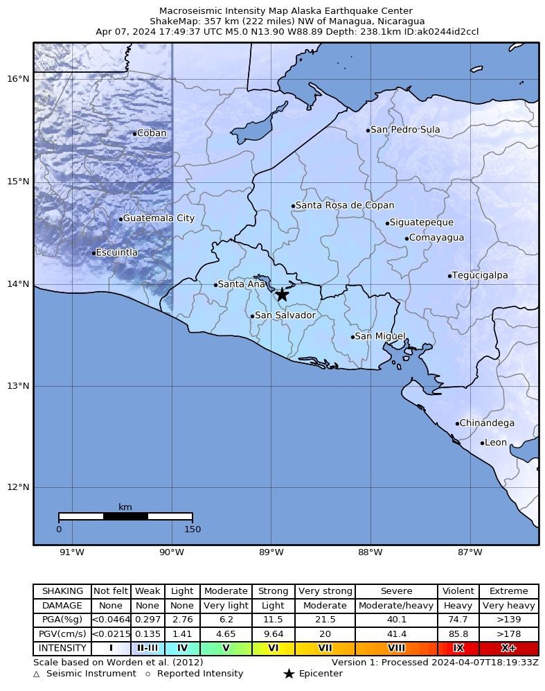
San Martín (11 km SW of epicenter) [Map] / Moderate shaking (MMI V) / vertical swinging (up and down) / 5-10 s : Fue fuertecito, de un solo le hizo hacia los lados y arriba


A strong magnitude 5.0 earthquake hit 26 km (16 mi) away from San Salvador, San Salvador, ![]() El Salvador, in the morning of Sunday, Apr 7, 2024 at 11.49 am local time (America/El Salvador GMT -6). The quake had a moderate depth of 193 km (120 mi) and was reported felt by some people near the epicenter.
El Salvador, in the morning of Sunday, Apr 7, 2024 at 11.49 am local time (America/El Salvador GMT -6). The quake had a moderate depth of 193 km (120 mi) and was reported felt by some people near the epicenter.
No significant damage or impact is expected from this quake and no particular alert was issued.
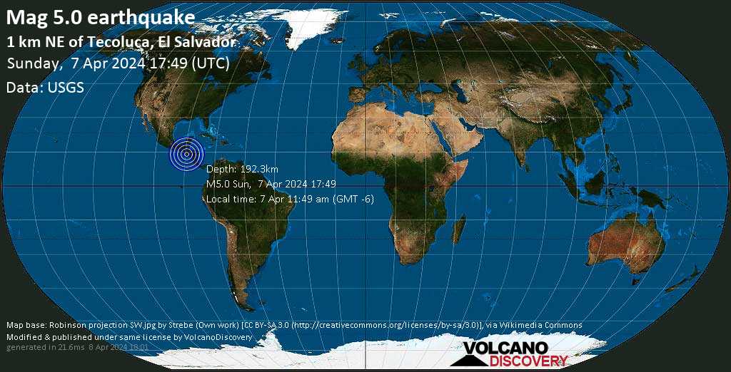
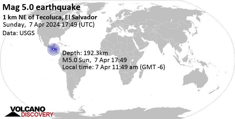
| Date & time | Apr 7, 2024 17:49:32 UTC - |
| Local time at epicenter | Sunday, Apr 7, 2024, at 11:49 am (America/El Salvador GMT -6) |
| Status | Confirmed (manually revised) |
| Magnitude | 5.0 |
| Depth | 193 km |
| Epicenter latitude / longitude | 13.8143°N / 88.9836°W |
| Seismic antipode | 13.8143°S / 91.0164°E |
| Shaking intensity | III Weak shaking near epicenter |
| Felt | 1 report |
| Primary data source | USGS (United States Geological Survey) |
| Nearest volcano | Guazapa (18 km / 11 mi) |
| Weather at epicenter at time of quake | Overcast Clouds  31.7°C (89 F), humidity: 34%, wind: 2 m/s (3 kts) from NE 31.7°C (89 F), humidity: 34%, wind: 2 m/s (3 kts) from NE |
| Estimated seismic energy released | 2 x 10¹² joules (554 megawatt hours, equivalent to 477 tons of TNT) | about seismic energy |
Distance |
Place | Max. shaking intensity(*) | Region | Country |
|---|---|---|---|---|
| 2 km (1 mi) N of epicenter |
Tenancingo (pop: 1,010) |
III: Weak |
Cuscatlan | |
| 8 km (5 mi) SE of epicenter |
San Martin (pop: 39,400) |
III: Weak |
Cuscatlan | |
| 12 km (8 mi) SE of epicenter |
Cojutepeque (pop: 48,400) |
III: Weak |
Cuscatlan | |
| 15 km (9 mi) N of epicenter |
Suchitoto (pop: 5,740) |
III: Weak |
Cuscatlan | |
| 18 km (11 mi) SW of epicenter |
Ilopango (pop: 38,900) |
III: Weak |
San Salvador | |
| 19 km (12 mi) SE of epicenter |
San Sebastian (pop: 7,330) |
III: Weak |
San Vicente | |
| 20 km (13 mi) SW of epicenter |
Soyapango (pop: 329,700) |
III: Weak |
San Salvador | |
| 21 km (13 mi) W of epicenter |
Apopa (pop: 112,200) |
III: Weak |
San Salvador | |
| 22 km (13 mi) W of epicenter |
Guazapa (pop: 11,000) |
III: Weak |
San Salvador | |
| 22 km (14 mi) SW of epicenter |
Delgado (pop: 71,600) |
III: Weak |
San Salvador | |
| 23 km (15 mi) SW of epicenter |
Cuscatancingo (pop: 44,400) |
III: Weak |
San Salvador | |
| 24 km (15 mi) SW of epicenter |
Mexicanos (pop: 160,300) |
III: Weak |
San Salvador | |
| 25 km (16 mi) N of epicenter |
Chalatenango (pop: 19,400) |
III: Weak |
Chalatenango | |
| 25 km (16 mi) SW of epicenter |
Santo Tomas (pop: 14,600) |
III: Weak |
San Salvador | |
| 26 km (16 mi) SW of epicenter |
San Salvador (pop: 526,000) |
III: Weak |
San Salvador | |
| 27 km (17 mi) NW of epicenter |
Aguilares (pop: 21,400) |
III: Weak |
San Salvador | |
| 27 km (17 mi) SW of epicenter |
San Marcos (pop: 54,600) |
III: Weak |
San Salvador | |
| 28 km (18 mi) SE of epicenter |
San Vicente (pop: 41,500) |
III: Weak |
San Vicente | |
| 31 km (19 mi) W of epicenter |
Quezaltepeque (pop: 28,900) |
III: Weak |
La Libertad | |
| 33 km (21 mi) S of epicenter |
Santiago Nonualco (pop: 9,490) |
III: Weak |
La Paz | |
| 34 km (21 mi) SW of epicenter |
Antiguo Cuscatlan (pop: 33,800) |
III: Weak |
La Libertad | |
| 41 km (26 mi) W of epicenter |
San Juan Opico (pop: 7,130) |
III: Weak |
La Libertad | |
| 41 km (26 mi) SW of epicenter |
Zaragoza (pop: 11,700) |
III: Weak |
La Libertad | |
| 49 km (31 mi) NW of epicenter |
Nueva Concepcion (pop: 9,990) |
III: Weak |
Chalatenango | |
| 52 km (32 mi) SW of epicenter |
La Libertad (pop: 16,900) |
III: Weak |
La Libertad | |
| 56 km (35 mi) W of epicenter |
Armenia (pop: 15,000) |
III: Weak |
Sonsonate | |
| 67 km (42 mi) SE of epicenter |
Santiago de Maria (pop: 15,000) |
III: Weak |
Usulutan | |
| 75 km (47 mi) W of epicenter |
Izalco (pop: 19,200) |
III: Weak |
Sonsonate | |
| 75 km (47 mi) SE of epicenter |
Puerto El Triunfo (pop: 19,100) |
III: Weak |
Usulutan | |
| 77 km (48 mi) NW of epicenter |
Metapan (pop: 19,100) |
III: Weak |
Santa Ana | |
| 78 km (48 mi) W of epicenter |
Chalchuapa (pop: 32,300) |
III: Weak |
Santa Ana | |
| 79 km (49 mi) W of epicenter |
Sonzacate (pop: 15,400) |
III: Weak |
Sonsonate | |
| 81 km (50 mi) W of epicenter |
Sonsonate (pop: 59,500) |
III: Weak |
Sonsonate | |
| 84 km (52 mi) SE of epicenter |
San Rafael Oriente (pop: 19,100) |
III: Weak |
San Miguel | |
| 93 km (57 mi) NW of epicenter |
Esquipulas (pop: 20,700) |
II: Very weak |
Chiquimula | |
| 94 km (58 mi) W of epicenter |
Ahuachapan (pop: 34,100) |
II: Very weak |
Ahuachapan | |
| 94 km (58 mi) E of epicenter |
San Miguel (pop: 161,900) |
II: Very weak |
San Miguel | |
| 94 km (59 mi) W of epicenter |
Acajutla (pop: 22,800) |
II: Very weak |
Sonsonate | |
| 96 km (60 mi) E of epicenter |
San Francisco (pop: 16,200) |
II: Very weak |
Morazan | |
| 97 km (61 mi) NW of epicenter |
Asuncion (pop: 15,600) |
II: Very weak |
Asuncion Mita, Jutiapa |
| Place | Distance from epicenter | Average reported Shaking Intensity | Nr. of reports |
|---|---|---|---|
| Soyapango, San Salvador, (Pop.: 329,708) | 20 km (13 mi) SW of epicenter | V: Moderate shaking | 1 |
| Mag | Depth | Time GMT 2024-04-7 |
Epicenter | Agency |
|---|---|---|---|---|
| 5.0 | 193 km 120 mi |
17:49:32 | 1 km NE of Tecoluca, El Salvador | USGS (United States Geological Survey) |
| 4.7 | 212 km 132 mi |
17:49:35 | El Salvador 33 km (20 mi) epicenter difference with USGS |
GFZ (German Research Centre for Geosciences) |
| 5.0 | 199 km 123 mi |
17:49:33 | el Salvador 2.5 km (1.5 mi) epicenter difference with USGS |
EMSC (European-Mediterranean Seismological Centre) |
| 4.2 | 178 km 111 mi |
17:49:34 | 1 km NE of Tecoluca, El Salvador 16 km (10.2 mi) epicenter difference with USGS |
INETER |
| 5.0 | 10 km 6.2 mi (*) |
17:49:32 | El Salvador 2.2 km (1.3 mi) epicenter difference with USGS |
IRIS (Incorporated Research Institutions for Seismology) |
Date and Time GMT | Mag Depth | Distance | Region | Details |
|---|---|---|---|---|
| Apr 7, 2024 11:49 am (El Salvador) 6 weeks ago | 5.0 193 km | 0 km - This quake | Cuscatlan, 26 km NE of San Salvador, San Salvador, El Salvador Main Shock (this quake) | More |