Mayotte Island Volcano
Updated: 14. Mai 2024 22:40 GMT -
Shield volcano 660 m / 2,165 ft
France, Western Indian Ocean, -12.83°S / 45.17°E
Aktueller Status: normal / ruhend (1 von 5)
France, Western Indian Ocean, -12.83°S / 45.17°E
Aktueller Status: normal / ruhend (1 von 5)
Last update: 13 Okt 2023 (Submarine eruption off the East coast of Mayotte)
Mayotte, located in the Mozambique Channel between the northern tip of Madagascar and the eastern coast of Africa, consists two main volcanic islands, Grande Terre and Petite Terre, and roughly twenty islets within a barrier-reef lagoon complex.
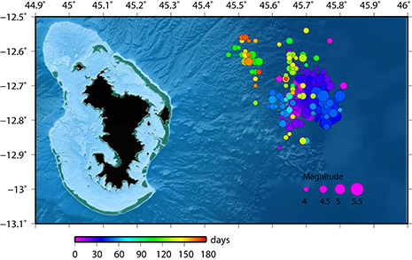
A submarine eruption occurred from a vent approx. 50 km east of the islands during 2018-19, first detected by intense seismic activity and significant eastward shifts in GPS position of the Mayotte island itself, and later observed during submarine surveys.
[smaller] [larger]
Ausbrüche des Mayotte Island: 2018 (3 Jul) - 2019 (around 20 Aug)
2050 BC ± 500 years
Letzte Erdbeben in der Nähe
| Uhrzeit | Mag. / Tiefe | Entfernung / Ort | |||
| 13. Mai. 12:17 (Mayotte) | 1.7 38 km | 21 km östlich | Info | ||
| 13. Mai. 03:40 (Mayotte) | 1.3 41 km | Info | |||
| Freitag, 10. Mai 2024 GMT (1 Beben) | |||||
| 10. Mai. 05:40 (Mayotte) | 1.8 39 km | 23 km nordöstlich | Info | ||
| Dienstag, 7. Mai 2024 GMT (1 Beben) | |||||
| 7. Mai. 04:02 (Mayotte) | 1.4 32 km | Info | |||
| Sonntag, 5. Mai 2024 GMT (1 Beben) | |||||
| 5. Mai. 05:22 (Mayotte) | 1.5 41 km | 20 km östlich | Info | ||
| Donnerstag, 2. Mai 2024 GMT (1 Beben) | |||||
| 3. Mai. 02:39 (Mayotte) | 1.4 36 km | Info | |||
Beschreibung
Mayotte Island in the Mozambique Channel between the northern tip of Madagascar and the eastern coast of Africa consists of two volcanoes with diverse geochemistry that were active from the Pliocene to the Holocene. Lavas on the NE were active from about 4.7 to 1.4 million years and on the south from about 7.7 to 2.7 million years. Mafic activity resumed on the north from about 2.9 to 1.2 million years and on the south from about 2 to 1.5 million years. Morphologically youthful-looking maars are present on Mayotte Island, and Zinke et al. (2003) found several pumice layers of Holocene age in gravity cores on the barrier reef-lagoon complex at Mayotte.---
Smithsonian / GVP volcano information
Ausbrüche des Vulkans Mayotte Island
2018-2019 submarine eruption
A submarine eruption occurred during 2018-19 at the ocean floor approx. 50 km east of Mayotte Island. The eruption produced vast submarine lava flows. It was detected by substantial earthquake activity and shifts in the GPS position of the main island. ...mehr Infos
A submarine eruption occurred during 2018-19 at the ocean floor approx. 50 km east of Mayotte Island. The eruption produced vast submarine lava flows. It was detected by substantial earthquake activity and shifts in the GPS position of the main island. ...mehr Infos
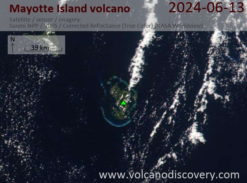
Latest satellite images