Contact | RSS | EN | DE | EL | ES | FR | IT | RU

Barren Island volcano, Indian Ocean: news & activity updates

Updated: 1 mai 2024 20:39 GMT-
dernier (2024) | 2023 | 2022 | Archive

Barren Island volcano (Andaman Islands, India) - Smithsonian / USGS Weekly Volcanic Activity Report for 3 April-9 April 2024 (New Activity / Unrest)

mer., 10 avril 2024, 14:00
Eruptive activity at Barren Island continued according to notices from the Darwin VAAC. Ash plumes identified in satellite images during 2-3 April rose 0.9-1.5 km (3,000-5,000 ft) a.s.l. and drifted SW and W. Read all

Barren Island volcano (Andaman Islands, India) - Smithsonian / USGS Weekly Volcanic Activity Report for 27 March-2 April 2024 (New Activity / Unrest)

mer., 3 avril 2024, 18:00
According to the Darwin VAAC eruptive activity at Barren Island produced ash plumes during 28 March-1 April. Ash plumes identified in satellite images at 1320 and 1930 on 28 March rose to 2.4 km (8,000 ft) a.s.l. and drifted NW. Read all
Montrer plus

Documentation:


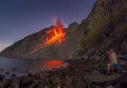
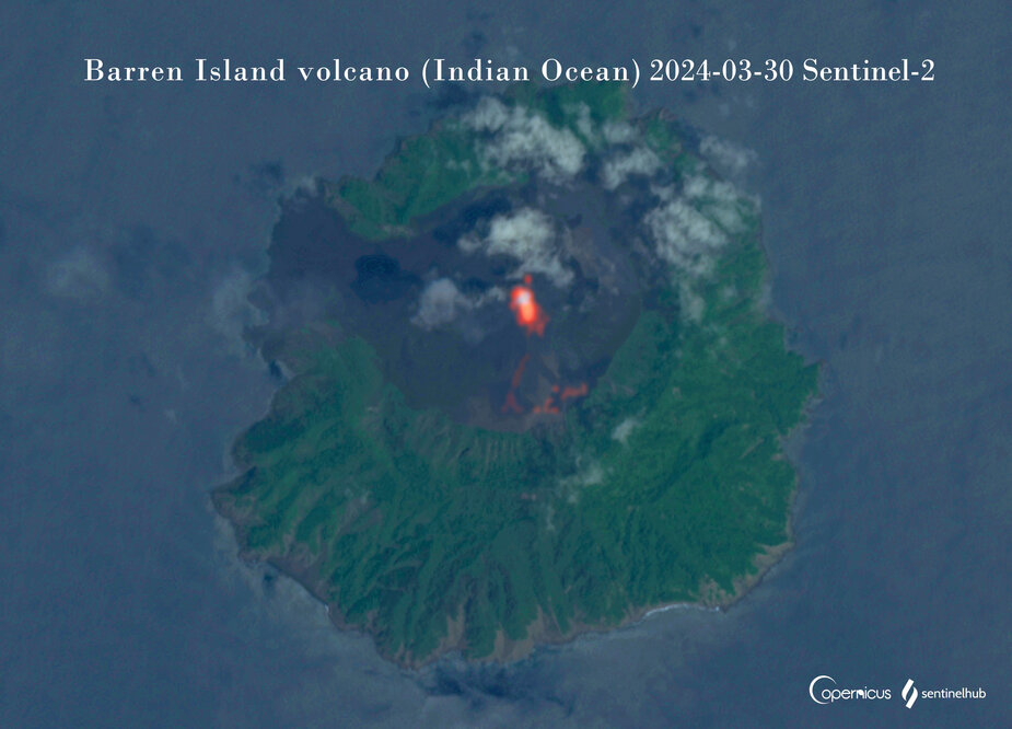
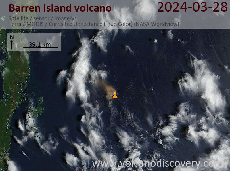
L'île Barren, une possession de l'Inde située dans la mer d'Andaman, à environ 135 km au nord-est de Port Blair, dans les îles Andaman, contient l'unique volcan historiquement actif, le long de l'extension N-S de l'arc volcanique, entre Sumatra et la Birmanie, le volcan Myanmar. Les 354 mètres de haut de l'île, correspondent au sommet du volcan qui s'élève depuis les profondeurs à environ 2250 m; Cette petite île, inhabitées, de 3 km-de large contient une caldera d'à peu près de 2 km-de large avec des parois de 250-350 m de hauteur; la caldera, qui est ouverte sur la mer à l'Ouest, a été formé au cours d'une éruption explosive majeure dans la fin du Pléistocène et qui produisit des coulées pyroclastiques (nuées ardentes) et des dépôts de déferlantes. La morphologie du nouveau cône pyroclastique, qui a été édifié au centre de la caldeira a variée au cours des éruptions historiques; Les coulées de Lave ont rempli une grande partie du plancher de la caldeira et ont atteintes la mer le long de la côte occidentale au cours des événements éruptifs dans le 19ème siècle et plus récemment en 1991 et 1995.

---
Source: GVP, Smithsonian Institution

Stratovolcano 354 m / 1,161 ft.
Indian Ocean, 12.28°N / 93.86°E
Condition actuelle: en éruption (4 sur 5) Eruptions du volcan Barren Island:
1787, 1789, 1795, 1803-04, 1852(?), 1991, 1994-95, 2005-2006, 2015, 2016, 2018, 2019
Style éruptif tipique
Explosive
Location map of Barren Island.
Découvrez notre app gratuite !
Volcanoes & Earthquakes - new app for Android
Android | Version iOS

Plus sur VolcanoDiscovery

Why is there advertising on this site?

Support us - Help us upgrade our services!

We truly love working to bring you the latest volcano and earthquake data from around the world. Maintaining our website and our free apps does require, however, considerable time and resources.
We need financing to increase hard- and software capacity as well as support our editor team. We're aiming to achieve uninterrupted service wherever an earthquake or volcano eruption unfolds, and your donations can make it happen! Every donation will be highly appreciated. If you find the information useful and would like to support our team in integrating further features, write great content, and in upgrading our soft- and hardware, please make a donation (PayPal or Online credit card payment).

Planned features:Thanks to your past donations, these features have been added recently:
Download and Upgrade the Volcanoes & Earthquakes app to get one of the fastest seismic and volcano alerts online:
Android | IOS
Thank you!
Copyright: VolcanoDiscovery ou autres sources indiquées.
Utilisation des documents: Les textes, les images et les vidéos de ce site internet sont protégées par copyright. Toute reproduction et tout usage sans accord préalable ne sont pas autorisés. Si vous désirez acquérir pour certains documents (photos, vidéos, textes ou autres) le droit de reproduction, d'édition et, plus généralement, de toute utilisation destinée à un usage public, qu'elle soit commerciale ou pas, vous êtes priés de nous contacter.
Volcanoes & Earthquakes
VolcanoDiscovery Home
Volcans | Séismes | Photos | Actualités | App
Adventure & Study Travel
Tours to Volcanoes and Volcanic Areas: walking tours, photo tours, study tours
Voyages |
Get our newsletter!
Company info
Contact | Mentions légales | Terms & conditions
Follow us
Follow us on facebook Follow us on Instagram Follow us on Twitter Visit our Youtube channel
EN | DE | EL | ES | FR | IT | RU
VolcanoDiscovery GmbH, Germany, Reg. nr.: HRB 103744, EU Tax Id: DE 297 465 123 owned and created by
Dr. Tom Pfeiffer, volcanologist, volcano photographer, tour organizer member of
IAVCEI
IAVCEI
Vulkanologische Gesellschaft
Volcanological Society
Ecotourism Greece
Ecotourism Greece
RUV insurance
Insured by R+V
VolcanoDiscovery © 2004- All Rights Reserved | Privacy - Changer Préférences