Contact | RSS | EN | DE | EL | ES | FR | IT | RU

Volcanoes of the Philippines

Central Philippines (15 volcanoes)

Alto | Biliran | Cabalian | Cancajanag | Canlaon | Cuernos de Negros | Hingatungan | Ilihan | Lobi | Mahagnao | Mandalagan | Maripipi | Nelangaapan | Pacdahauan | Silay

Luzon Island (33 volcanoes)

Ambalatungan | Amorong | Anilao Hill | Arayat | Banahaw | Binuluan | Bulusan | Cagua | Cariliao | Cone-Culasi | Corregidor | Dagit-Dagitan | Gate Mountains | Iriga | Isarog | Labo | Laguna | Makiling | Malepunyo | Malinao | Malindig | Mariveles | Masaraga | Mayon | Natib | Panay | Patoc | Pinatubo | Pocdol Mountains | San Pablo | Sangay (Philippines) | Santo Tomas | Taal

Mindanao (20 volcanoes)

Ampiro | Apo | Balatukan | Balut | Blit | Hibok-Hibok | Imbing | Kaladis | Kalatungan | Kitabud | Latukan | Leonard Range | Makaturing | Malindang | Matutum | Musuan | Paco | Parker | Quezon | Ragang

North of Luzon (6 volcanoes)

Babuyan Claro | Camiguin de Babuyanes | Didicas | Iraya | Matarem | Unnamed

Sulu Islands (1 volcano)

Jolo
[smaller] [bigger]
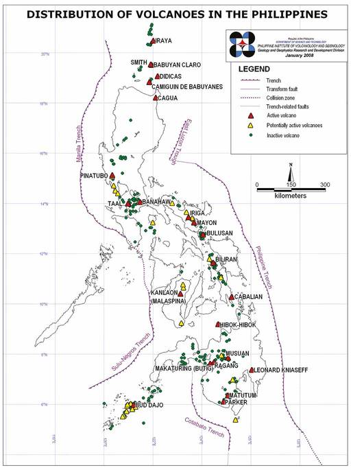
Volcanoes in the Philippines
Map of volcanoes in the Philippines and major tectonic features (PHILVOLCS 2008)

Volcano list

Latest volcano news
Wed, 5 Jun 2024, 14:00

Mayon volcano () - Smithsonian / USGS Weekly Volcanic Activity Report for 29 May-4 June 2024 (New Activity / Unrest)

The Tokyo VAAC reported that at 1529 on 30 May an ash plume from Mayon rose to 2.7 km (9,000 ft) a.s.l. and drifted N based on information from PHIVOLCS. Ash was not identified in satellite images. ... Read all
Wed, 5 Jun 2024, 14:00

Kanlaon volcano () - Smithsonian / USGS Weekly Volcanic Activity Report for 29 May-4 June 2024 (New Activity / Unrest)

PHIVOLCS reported that at 1851 on 3 June an explosive eruption at Kanlaon ejected incandescent material and produced a voluminous ash plume that rapidly rose 5 km above the vent and drifted W. Pyroclastic density currents generated from column collapses traveled 2-3 km down the S and SE flanks based on webcam views. The eruption was recorded by all 10 seismic stations, three infrasound stations, and webcams, and lasted six minutes based on the seismic data. ... Read all
Why is there advertising on this site?
Sources: VolcanoDiscovery / VolcanoAdventures and other sources as noted.
Use of material: Most text and images on our websites are owned by us. Re-use is generally not permitted without authorization. Contact us for licensing rights.
Volcanoes & Earthquakes
VolcanoDiscovery Home
Volcanoes | Earthquakes | Photos | Volcano News | App
Adventure & Study Travel
Tours to Volcanoes and Volcanic Areas: walking tours, photo tours, study tours
Tours & Dates | FAQ | About us
Get our newsletter!
Company info
Contact | Legal info | Terms & conditions
Follow us
Follow us on facebook Follow us on Instagram Follow us on Twitter Visit our Youtube channel
EN | DE | EL | ES | FR | IT | RU
VolcanoDiscovery GmbH, Germany, Reg. nr.: HRB 103744, EU Tax Id: DE 297 465 123 owned and created by
Dr. Tom Pfeiffer, volcanologist, volcano photographer, tour organizer member of
IAVCEI
IAVCEI
Vulkanologische Gesellschaft
Volcanological Society
Ecotourism Greece
Ecotourism Greece
RUV insurance
Insured by R+V
VolcanoDiscovery © 2004- All Rights Reserved | Privacy - Cookie Settings
Cookie-free, privacy-friendly web stats