Ruang Volcano
Updated: 22. Mai 2024 02:48 GMT -
Stratovolcano 725 m / 2,379 ft
North Sulawesi (Indonesien), 2.28°N / 125.43°E
Aktueller Status: Schwache Aktivität oder Ausbruchswarnung (3 von 5)
North Sulawesi (Indonesien), 2.28°N / 125.43°E
Aktueller Status: Schwache Aktivität oder Ausbruchswarnung (3 von 5)
Last update: 15 Mai 2024 (Smithsonian / USGS Weekly Volcanic Activity Report)
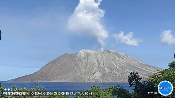
Ruang volcano is the southernmost volcano in the Sangihe Island arc, north of Sulawesi Island. The 4 x 5 km island volcano rises to 725 m across a narrow strait SW of the larger Tagulandang Island. The summit of Ruang volcano contains a crater partially filled by a lava dome initially emplaced in 1904. Explosive eruptions recorded since 1808 have often been accompanied by lava dome formation and pyroclastic flows that have damaged inhabited areas. Eruptions in 1870 and 1871 also caused fatalities.
[smaller] [larger]
Ausbrüche des Ruang: 1808, 1836(?), 1840, 1856, 1870, 1871, 1874, 1889, 1904-05, 1914-15, 1949, 1996(?), 2002
Letzte Erdbeben in der Nähe
| Uhrzeit | Mag. / Tiefe | Entfernung / Ort | |||
Latest satellite images